Welcome!
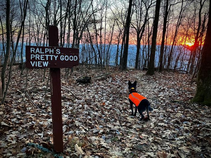
A hike on the Allegheny Front Trail is a wonderful, wet, and wild adventure through Moshannon State Forest. This 41.5-mile hiking trail forms a massive loop around Black Moshannon State Park, complete with spectacular overlooks and some shoe-soaking stream crossings. The full hike is estimated to take around 3 days, and there’s a lot to explore in that amount of time. You’ll wind your way through valleys, marshes, and even “tunnels” of rhododendron bushes. There are a few steep points and rocky areas, but most of the trail is actually fairly mild. Highlights include historical remnants from splash dams and a forge, a section through Black Moshannon State Park itself, and six major vistas. Two of the best are Ralph’s Pretty Good View and Ralph’s Majestic Vista—you decide which one you think is better.
The Allegheny Front Trail includes shared sections with two other paths: the Rock Run Trails and the Moss-Hanne Trail. It also contains a segment along Moshannon Creek, but don’t drink from here. The creek is nicknamed “Red Mo” for its unnatural red-orange color, which results from hazardous mining residue in the water. Black Moshannon Creek and various smaller streams are all better options for hydration.
The name “Moshannon” comes from the Seneca Native Americans, who called what is now Moshannon Creek “Moss-Hanne,” meaning “moose stream.” Even as white settlers began to flood other parts of the state in the late 1700s, the forested region around Moss-Hanne remained mostly undeveloped because of its location along the tough terrain of the Allegheny Front. Allegedly, the trees here were so thick that sunlight couldn’t reach the ground! That changed in the 1850s, when extensive timbering laid waste to much of the forest; the stumps of giant white pines still attest to the devastation. Once lumber companies abandoned the region, the forest finally began to recover, largely thanks to the efforts of the Civilian Conservation Corps during the 1930s. Many years later, the Allegheny Front Trail was completed in 2001. One of the state’s newest backpacking loops, it encompasses some of the most spectacular hiking Pennsylvania has to offer.
Blazes: The Allegheny Front Trail is marked with yellow blazes. Additional red blazes indicate that a region is available for mountain biking and horseback riding, while extra blue blazes mean that cross-country skiing is permitted. Additional connector trails come in a variety of colors, but many of these are also blazed yellow.
Caution: Do not drink the water from Moshannon Creek, even with a filtration device. It contains hazardous abandoned mine drainage.
Hunting: The trail passes through areas that permit hunting during appropriate seasons. For your own safety, wear orange during these periods. Visit the PA Game Commission Website for more information on hunting seasons.
Note: Dogs are allowed off-leash in the remote country (only in the park) of the AFT.
This trail is managed by the Pennsylvania Department of Conservation and Natural Resources (DCNR). For more information, visit the Moshannon State Forest Website. Contact the DCNR at fd09@pa.gov.
Tram Road: From Philipsburg, take PA-504 East for 13.1 miles. Parking will be on the left, just past Tram Road.
Six Mile Run: From Philipsburg, take PA-504 East for 6.1 miles. Parking will be on the right, just past Six Mile Run.
Dug Road: From US-322 (in Centre County), turn northeast onto Strawband Beaver Road and continue for 5 miles. Turn left onto Dug Road and continue for 1 mile. The trailhead will be at the intersection with Shirks Road.
Beaver Road: From Philipsburg, take PA-504 East for 8.7 miles. Turn right onto SR-3032 and continue for 2.1 miles. Parking will be on the right, at the intersection with Shirks Road.