Welcome!
It might sound spooky, but the Forbidden Drive in Wissahickon Valley Park is actually one of the most pleasant places in Philadelphia. This 5.4-mile pathway is so welcoming, in fact, that it was honored as the Pennsylvania Trail of the Year in 2018. It winds along the banks of Wissahickon Creek, through an 2,040-acre park that offers a surprisingly forested oasis; the area also happens to be an Important Birding Area, according to the Audubon Society. If you’re in the city, you’ll find few places as natural or beautiful as the steep-sided Wissahickon Valley, also a designated National Natural Landmark.
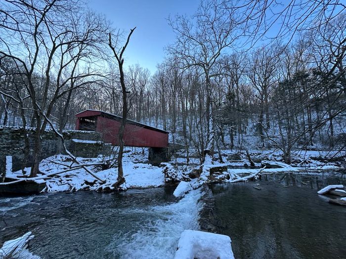
At its southern end, Forbidden Drive begins only a short distance from where Wissahickon Creek flows into the Schuylkill River. This junction is an important historic site, and it was the location of the Revolutionary War’s Battle of Germantown as well as the historic Rittenhouse Town. Heading north along the creek’s east bank, you’ll quickly pass by one of the strangest trailside features: a Roman sarcophagus estimated to be around 1,800 years old. Nobody knows how it got there, but the ancient treasure was repurposed as a watering trough for horses sometime in the late 1900s. Soon after, the route crosses to the creek’s west bank over the Blue Stone Bridge. Features on this side include the Gorgas Creek Cave and the Valley Green Inn, an old 1850s roadhouse that now serves as a park-operated restaurant. You’ll also pass by the bright red paneling of the Thomas Mill Bridge—the only covered bridge still standing in Philly—before reaching the trail’s northern terminus at the Philadelphia-Montgomery County line, near the Morris Arboretum. You can choose to go up the hill and visit the Wissahickon Environmental Center or the Andorra Natural Area, which plays host to one of the park’s two meadows (be mindful: this area is for hikers and equestrians only). You can either continue northward on the Wissahickon Green Ribbon Trail or make the return journey towards Germantown. If you’re up for more adventure, Wissahickon Valley Park still has more than 50 miles of trail left for you to explore. This network also provides access to the Schuylkill River Trail, thus linking the Forbidden Drive to Philly’s Circuit Trails network via the Lincoln Drive paved trail.
The name “Wissahickon” originates from the region’s original inhabitants, the Lenni Lenape Native Americans, and roughly translates to either “catfish creek” or “yellowish stream.” The creek-side was an industrial center for many years, its abundant mills and factories accessed via a highway known as the Wissahickon Turnpike. However, as concerns emerged over the quality of water for local residents in the late 1800s, the city of Philadelphia began setting aside the Wissahickon Valley as a public park. It closed the Wissahickon Turnpike in 1920, and the road became the Forbidden Drive—so called because cars were forbidden to drive on it. The trail’s history as a highway also explains why it is so wide; unlike most multi-use paths, the drive’s average width is as high as 25 feet. That extra width just means there’s more trail to enjoy for the over 2 million hikers, bikers, and equestrians who trek the Forbidden Drive every year.
Hours: The trail remains open from 6:00 a.m. to 1:00 a.m. From December through March, hours are restricted to 6:00 a.m. to 8:00 p.m.
Trail specifications: The average width is 25 feet, and the average grade is 3%.
Caution: No swimming is permitted in Wissahickon Creek.
For bikers: Though the trail may be ridden with a road bike, the crushed-stone surface may be better suited to a gravel bike or mountain bike that will provide a little more cushioning in bumpy sections.
This trail is located within Wissahickon Valley Park, which is owned and operated by Philadelphia Parks and Recreation (PPR). Friends of Wissahickon works in partnership with PPR to steward the park. Contact Friends of Wissahickon at https://fow.org/contact-fow/.
Ten Box (southern terminus): From Philadelphia, take John F Kennedy Boulevard west to cross the Schuylkill River. Immediately after crossing, turn right and use the right lane to get onto I-76 West. Continue for 3.9 miles. Take exit 340B to get on US-1 North and continue for 1.5 miles. Take the exit towards Wissahickon Avenue North and merge onto Roberts Avenue. Take the first right onto Wissahickon Avenue and continue for 1.3 miles. Turn left onto West Rittenhouse Street, then left again onto Lincoln Drive and continue for 0.3 mile. Parking will be on the right, just after the sign for “Forbidden Drive.”
Valley Green Inn: From Philadelphia, follow the above directions to get on I-76 West. Once on I-76 West, continue for 3.9 miles. Using the left lane, take exit 339 to merge onto US-1 South and continue for 0.8 mile. Merge back onto I-76 West and continue for 1.6 miles. Take exit 338 for Belmont Avenue. At the end of the ramp, turn right onto Green Lane, then take the first left onto Main Street. Take the first right onto Leverington Avenue and continue for 1.2 miles. Turn left onto Henry Avenue and continue for 1.6 miles. Turn right onto Wises Mill Road and continue for 0.9 mile. Parking will be at the end of Wises Mill Road.
Bells Mill: From Philadelphia, follow the directions immediately above to get on Leverington Avenue. Once on Leverington Avenue, take the second left onto Umbria Street and continue for 0.8 mile. Turn right onto Domino Lane and continue for 0.6 mile. Turn left onto Ridge Avenue and continue for 1.8 miles. Turn right onto Bells Mill Road and continue for 0.9 mile. Parking will be on the right.
Northwestern Avenue (northern terminus): From Philadelphia, follow the directions immediately above to get on Ridge Avenue. Once on Ridge Avenue (which becomes Ridge Pike) continue for 2.6 miles. Turn right onto Church Road, then take the first right onto Park Avenue. Take the first left onto Andorra Road and continue for 1 mile. When Andorra Road ends, turn right onto Northwestern Avenue. Parking will be immediately on the right.